RISCO-BANGLA : Contribution of waves to coastal hazards along the Bangladeshi coast
Funded by CNRS, IRD (2019)
Project leader: Xavier Bertin, LIENSs
Partners: LEGOS
The Ganges-Brahmaputra Delta (GBD) is a densely populated area and one of the most vulnerable in the world to coastal hazards. This situation of extreme vulnerability, already very worrying, is worsening due to climate change as well as local anthropogenic factors. The RISCO-BANGLA project aims to carry out for the first time bathymetry and bottom ocean pressure measurements in the coastal areas of the GBD, in order to characterize sea states and better understand their contribution to coastal risks. These observations will allow the calibration of spectral wave models, which are currently used by several international teams with default parameters, which we suspect to be unsuitable due to the very shallow slopes of the seabed in this region. These data will then allow us to study for the first time the infra-gravity waves along the GBD, which seem to contribute substantially to marine submersion during cyclones. By improving our knowledge of coastal risks, RISCO-BANGLA should allow an improvement of their management in this high-stake region. Figure 1 illustrates the experimental device used during the first RISCO-BANGLA in situ experiment carried out in October 2019, to measure the bathymetry of the near-shore zone and to deploy pressure recorders.
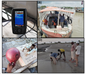
Figure 1 : (A) Portable Garmin monitor for low-cost acquisition and visualization of bathymetric sonar data, (B) Kuakata fishermen’s boat used to carry out the bathymetric measurement campaign and deploy a pressure sensor in the subtidal zone, (C) structure allowing the deployment of this pressure sensor, and (D) deployment of one of the pressure sensors in the intertidal zone.
BAND-DINO : BANgladesh Dynamique Des INOndations (Flood Dynamics in Bangladesh)
Funded by CNES (2018-2020)
Project leader: Fabien Durand, LEGOS
Partners: LIENSs, IWFM-BUET
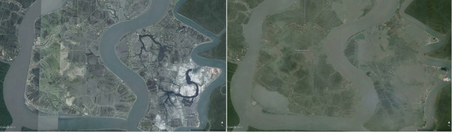
The main objective of the BAND-DINO project is to establish the mechanisms responsible for coastal flooding during tropical cyclones hitting the Ganges-Brahmaputra Delta (GBD). The approach consists in using a combination of spatial remote sensing of the extent of the flooded areas (high-resolution multi-spectral imagery) and a hydrodynamic numerical modeling platform implemented on the hydraulic continuum of the GBD. In particular, the project aims to specify the respective roles of the tide, the cyclonic surcote and the waves in the massive submersions that occur during extreme events. The project aims at analyzing the current climatic situation, and the situation expected at the end of the 21st century when the sea level will be significantly higher than the current level.
BanD-AID : Recherche collaborative sur le Delta du Bangladesh : Évaluation des causes des risques liés à l’élévation du niveau de la mer et développement intégré de la modélisation prédictive en vue de l’atténuation et de l’adaptation
Funded by Agence Nationale de la Recherche (FRANCE), the German Research Foundation (Germany), the National Science Foundation (United States)
Project leaders (France) : Fabrice Papa, Stéphane Calmant, LEGOS
Partners : The Ohio State University (United States), The University of Bonn (Germany), The University of Cologne (Germany), theTennessee Technological University (United States), The Institute of Water Modelling (India), The Curtin University (Australia), The University of Rajshahi (India), Observatoire Midi-Pyrenees (France)
Band-AID était un projet financé par le Belmont Forum dans le cadre de l’appel à proposition “Coastal 2012” portant sur la vulnérabilité, la résilience et l’adaptation des sociétés face aux aléas naturels côtiers multifactoriels. Band-AID avait pour objectif de mettre en place un système robuste d’analyse et de prévision du système terrestre (ESAPS) pour le Bangladesh, afin d’adapter/atténuer les risques côtiers, notamment l’élévation du niveau de la mer. Band-AID a permis de quantifier (1) les causes de l’élévation du niveau de la mer et des mouvement du sol, et (2) les interactions humaines qui régissent la vulnérabilité côtière au Bangladesh. Ces connaissances ont été utilisées pour le développement intégré, utilisant les sciences naturelles et sociales d’une modélisation prédictive robuste pour répondre à l’adaptation de l’élévation du niveau de la mer et d’autres risques sur les côtes du Bangladesh.